
SR 9/I-95 at SR 80/Southern Boulevard
Project Development and Environment (PD&E) Study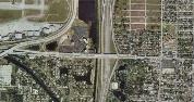
Project Description
This interchange was one of 17 interchanges studied as part of the I-95 Interchange Master Plan that reexamined the 2003 I-95 Interchange Master Plan Study and the SR 9 / I-95 mainline project. That project added a High Occupancy Vehicle (HOV) lane and auxiliary lanes from south of Linton Boulevard to north of PGA Boulevard in Palm Beach County and also included minor improvements to 8 interchanges. Overall, the I-95 Interchange Master Plan recommended new short-term and long-term improvements to interchanges based on changes in traffic volumes and updated design standards. The SR 9 / I-95 at SR 80 / Southern Boulevard interchange is located between the Forest Hill Boulevard interchange (1.45 miles to the south), and the Belvedere Road interchange (1.01 miles to the north), and in proximity to multiple municipalities including the City of West Palm Beach, Town of Cloud Lake, Town of Glen Ridge, and unincorporated Palm Beach County. This interchange project proposes to improve interchange operations to address traffic spillback onto SR 9 / I-95, reduce congestion, and increase safety. This project will also be developed with consideration to the potential extension of the I-95 Express Lanes through this interchange area.
This project will evaluate the No-Build and three Build alternatives for the interchange.
SR 9 / I-95 is currently a ten-lane, divided interstate freeway from north of the Congress Avenue interchange to north of the PGA Boulevard interchange providing four general purpose lanes and one High Occupancy Vehicle (HOV) lane in each direction. Auxiliary lanes are also provided in both the northbound and southbound directions on various segments throughout the corridor. The existing right-of-way varies as it approaches the interchange, but the typical right-of-way ranges from approximately 300 to 600 feet. As part of the Strategic Intermodal System (SIS) and one of two major expressways (Florida's Turnpike being the other) that connect the major employment centers and residential areas of Miami-Dade, Broward and Palm Beach Counties, SR 9 / I-95 serves an important role in facilitating the north-south movement of traffic in Southeast Florida.
Under the jurisdiction of the Florida Department of Transportation (FDOT), SR 80 / Southern Boulevard is an eight-lane divided, urban principal arterial designated as an SIS facility west of SR 9 / I-95, and a four-lane divided, urban principle arterial east of SR 9 / I-95. This east-west facility currently bridges over the South Florida Rail Corridor (SFRC) / CSX Railroad and SR 9 / I-95. SR 80 / Southern Boulevard at the SR 9 / I-95 interchange is a typical diamond configuration and has dual left-turn lanes and a single right-turn lane in both the eastbound and westbound directions to access the SR 9 / I-95 on-ramps. The existing right-of-way varies from approximately 135 feet east of SR 9 / I-95 to 180 feet west of SR 9 / I-95. Sidewalks and designated bicycle lanes are provided along both sides of SR 80 / Southern Boulevard within the area of influence.
Purpose and Need
The purpose of the project is to enhance overall traffic operations at the existing interchange of SR 9 / I-95 and SR 80 / Southern Boulevard by providing improvements to achieve acceptable Levels of Service (LOS) at the interchange in the future condition (2040 Design Year). Conditions along SR 80 / Southern Boulevard are anticipated to deteriorate below acceptable LOS standards if no improvements occur by 2040; the interchange will have insufficient capacity to accommodate the projected travel demand. The need for the project is based on the need to improve operational capacity, improve overall traffic operations in order to accommodate future growth and development, improve safety conditions, and enhance emergency evacuation and response times.
This project is anticipated to improve traffic operations at the SR 9 / I-95 and SR 80 / Southern Boulevard interchange and study area roadways / intersections by implementing operational and capacity improvements to meet the future travel demand projected as a result of Palm Beach County population and employment growth.
Based upon the traffic operations analysis conducted for the SR 9/I-95 at Southern Boulevard (SR-80) interchange and adjacent signalized intersections [documented in the I-95 (SR-9) Interchange at Southern Boulevard (SR-80) in Palm Beach County Interchange Concept Development Report], the existing AM and PM peak hour traffic conditions for the four study intersections along SR 80 / Southern Boulevard range from LOS A to D in the AM peak hour, and from LOS B to D in the PM peak hour. Without interchange improvements, the future year (2040) AM peak LOS will decline and range from B to F. PM peak hour LOS will range from C to F. Although all of the intersections along SR 80 / Southern Boulevard operate at LOS D or better under existing conditions, it should be noted that several of the individual through and turning movements at the intersections (which include the SR 9 / I-95 on / off ramp approaches) operate at LOS F during both the AM and PM peak periods. Without the proposed improvements, the intersections are projected to experience excessive delays and queuing, and operate below acceptable LOS standards by the 2040 Design Year.
Commercial retail / office, hotel and residential land uses are located adjacent to the interchange. Residential, hotel and commercial office uses are located along SR 80 / Southern Boulevard west of SR 9 / I-95. Predominantly residential and industrial uses are located to the west of Gem Lake Drive, while residential and commercial uses are located to the east of SR 9 / I-95. According to the Future Land Use Maps for Palm Beach County, the project area is to remain relatively unchanged.
Population within the vicinity of the interchange is anticipated to increase by approximately 12% from 2005 to 2035 with the majority of the growth occurring southeast of the SR 9 / I-95 at SR 80 / Southern Boulevard interchange. Employment is expected to increase by approximately 784% from 2005 to 2035 with major increases in the areas located and northeast and southwest of the interchange. These projections are based on data derived from the enhanced Southeast Regional Planning Model (SERPM) version 6.5, Managed Lanes Model (upgraded to include specific subarea improvements for the I-95 Interchange Master Plan). As such, the proposed improvements will be critical in supporting growth within the vicinity of the interchange and the overall vision of Palm Beach County.
The I-95 (SR-9) Interchange at Southern Boulevard (SR-80) in Palm Beach County Interchange Concept Development Report included a safety analysis of the project area. The total number of crashes in the three-year period 2010 through 2012 was 119, with 31% of those being rear-end type crashes, the predominant type of incident. FDOT’s high crash location reports, for the period 2010 through 2012, provide locations that have a higher crash rate as compared to crash rates for similar statewide roadways. Based on FDOT’s 2011 high crash location report, the SR 9 / I-95 at SR 80 / Southern Boulevard interchange is considered a high crash location.
The proposed improvements are anticipated to provide additional through and turn lanes, as well as interchange ramp improvements, to help reduce conflict points and the potential occurrence of collisions at the interchange.
SR 9 / I-95 and SR 80 / Southern Boulevard serve as part of the emergency evacuation route network designated by the Florida Division of Emergency Management. Also designated by Palm Beach County as evacuation facilities, SR 9 / I-95 and SR 80 / Southern Boulevard are critical in facilitating traffic flows during emergency evacuation periods as they connect other major arterials and highways of the state evacuation route network. This project is anticipated to improve emergency evacuation capabilities by enhancing connectivity and accessibility to SR 9 / I-95 and other major arterials designated on the state evacuation route network from the west and east, and increase the operational capacity of traffic that can be evacuated during and emergency event.